
Apple Maps Gets a Major Update in India! 300+ 3D Landmarks and AR Walking Directions Set to Challenge Google Maps
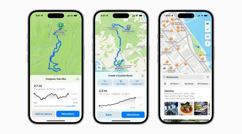
Apple Maps New Update India: Apple has introduced a major upgrade to its Apple Maps app in India, bringing a range of advanced navigation features designed specifically for Indian users. The latest update introduces more than 300 3D landmarks, Augmented Reality (AR) Walking Directions, improved Lane Guidance, Multi-Stop Routing and enhanced Natural Language Guidance.
The Cupertino-based technology giant says the new Apple Maps experience has been designed around India’s unique navigation requirements. With better road details, immersive visuals, regional language support and smarter navigation tools, Apple aims to make finding destinations easier and more convenient.
One of the biggest highlights is the addition of dual-language map labels, allowing users to view locations and street names in English alongside an Indian regional language. These improvements could make Apple Maps a stronger competitor to Google Maps, which has long dominated India’s navigation market.
Let’s take a detailed look at all the new Apple Maps features, how they work and what they mean for Indian users.
Apple Maps New Update in India: What’s New?
Apple has started rolling out a major update to its Maps application in India. The update focuses on improving navigation accuracy, map visuals and the overall user experience.
Unlike traditional navigation updates that primarily focus on directions and traffic information, Apple’s latest upgrade introduces several features designed to make digital navigation more interactive and practical.
The new update includes more than 300 3D landmarks, improved Natural Language Guidance, Lane Guidance, Multi-Stop Routing, Look Around, AR Walking Directions and Cycling Directions.
Apple has also expanded language support to make the application more accessible to people across different parts of India.
With these additions, Apple wants to offer users a more detailed understanding of their surroundings rather than simply showing them a route from one location to another.
300+ 3D Landmarks Bring Indian Cities to Life
One of the biggest highlights of the Apple Maps update is the introduction of more than 300 three-dimensional landmarks.
With this feature, users can explore important buildings, popular locations and major landmarks in a more realistic visual format.
Traditional digital maps generally display roads, buildings and other geographical details through relatively simple visual representations. However, 3D landmarks provide a more immersive experience by presenting selected structures with additional visual depth and detail.
This can make it easier for users to identify important locations while navigating unfamiliar areas.
For example, someone visiting a new city may find it easier to recognise a prominent building or shopping complex when it appears as a detailed 3D structure on the map.
This feature could be particularly useful for tourists, business travellers and people exploring unfamiliar neighbourhoods.
In a country like India, where many streets do not have clearly identifiable names, visual landmarks can play an important role in helping people navigate more confidently.
Natural Language Guidance Makes Navigation Smarter
Apple has also improved its Natural Language Guidance feature to make navigation instructions sound more conversational and easier to understand.
Traditional navigation systems often provide basic instructions such as turning left, turning right or continuing straight for a specified distance.
However, these instructions are not always sufficient, especially when users are travelling through complicated roads or unfamiliar neighbourhoods.
Apple aims to address this problem by incorporating more real-world details into navigation instructions.
The improved system can use identifiable roadside features, pillars and other physical reference points to help users understand where they need to go.
This could be particularly useful in Indian cities where several roads and narrow streets may not have clearly defined names.
Instead of relying entirely on street names, users can benefit from contextual information that makes directions easier to follow.
The improvement is expected to make everyday navigation more convenient, particularly in crowded urban areas.
Lane Guidance Helps Drivers Choose the Correct Lane
Another important addition is the improved Lane Guidance feature.
Driving through major Indian cities can be challenging because of complicated road networks, flyovers, elevated roads, service lanes and multiple turning options.
Choosing the wrong lane at the last moment can result in missed exits, unnecessary detours and additional travel time.
Apple Maps aims to make this process easier by helping drivers identify the correct lane before approaching a turn or entering an elevated road.
The feature provides lane-related guidance so users can prepare for upcoming manoeuvres in advance.
This could be especially beneficial for people driving through busy metropolitan areas such as Delhi, Mumbai, Bengaluru and Hyderabad.
By offering clearer lane instructions, Apple hopes to reduce navigation confusion and make driving more convenient.
However, drivers should always prioritise road safety and avoid interacting with their phones while driving.

Multi-Stop Routing Allows Users to Plan Up to 15 Stops
Apple Maps is also introducing an improved Multi-Stop Routing experience that could make trip planning considerably easier.
The feature allows users to add up to 15 stops to a single journey before starting their trip.
This means users no longer need to create separate routes every time they want to visit multiple destinations.
For example, someone planning to visit an office, shopping mall, bank, restaurant and a friend’s house can add these locations to one planned journey.
This is particularly useful for people who regularly travel between multiple destinations throughout the day.
Another major advantage is Apple’s ecosystem integration.
According to Apple, routes created on a Mac or iPad can automatically sync with an iPhone.
This allows users to plan their journeys on a larger screen and continue navigating through their iPhone while travelling.
The feature could be especially useful for business travellers, delivery professionals and people planning road trips.
Dual-Language Labels Bring Better Regional Language Support
India is home to a wide variety of languages, and Apple is addressing this diversity through its new Dual-Language Labels feature.
The feature allows users to view place names and road labels in English alongside an additional regional Indian language.
For example, users in New Delhi may see location names in both English and Hindi, while users in Mumbai may see English and Marathi labels.
This can make maps easier to understand for people who are more comfortable reading their regional language.
Apple Maps also supports several Indian languages, including:
- Hindi
- Bengali
- Gujarati
- Kannada
- Malayalam
- Marathi
- Tamil
- Telugu
- Punjabi
- Odia
- Urdu
This expanded language support represents an important step towards making digital navigation more accessible across India.
It could also help people who are visiting different states and are unfamiliar with local languages.
Look Around Feature Offers Immersive Street-Level Views
Apple Maps also includes the Look Around feature, which provides interactive street-level visual experiences.
The feature uses high-resolution photography and smooth transitions to help users explore selected locations from a street-level perspective.
Instead of viewing an area only through a traditional overhead map, users can explore what the surroundings actually look like.
For example, someone planning to visit a hotel, office, shopping complex or tourist attraction can use Look Around to get a better visual understanding of the surrounding area.
This can make it easier to recognise buildings, roads and nearby locations before arriving at a destination.
The feature is particularly useful for tourists and people travelling to unfamiliar neighbourhoods.
With improved visual details, Apple wants to make Maps feel more like an interactive exploration platform rather than just a conventional navigation application.
AR Walking Directions Bring Augmented Reality Navigation
AR Walking Directions is another major highlight of Apple’s latest Maps update.
AR stands for Augmented Reality, a technology that combines digital information with the real-world environment.
With AR-based walking guidance, users can receive step-by-step navigation instructions while exploring their surroundings.
Traditional walking navigation generally requires users to look at a map and understand which direction they need to follow.
AR guidance aims to make this process more intuitive by displaying digital directional indicators alongside the real-world view.
For example, someone walking through a crowded market, shopping district or unfamiliar city centre may find it easier to understand where to turn and which direction to follow.
This feature could be particularly useful for tourists, pedestrians and people visiting large public areas.
However, users should remain aware of their surroundings and avoid looking at their screens continuously while walking.
ETA Sharing Helps Friends and Family Track Your Journey
Apple Maps now also offers an Estimated Time of Arrival sharing feature.
ETA sharing allows users to communicate their expected arrival time with friends, family members or other contacts.
For example, if someone is travelling home from work or heading to meet a friend, they can share their estimated arrival information.
The recipient can then stay informed about the user’s journey and expected arrival.
This feature can be particularly helpful during long journeys, daily commutes and late-night travel.
It also reduces the need to repeatedly send messages explaining how far away someone is.
Siri Helps Users Report Accidents and Road Hazards
Apple Maps also allows users to report certain road incidents and hazards through Siri.
Users can report situations such as accidents, road hazards and speed checks while travelling.
These reports can help other drivers become aware of potential problems along their routes.
For example, if an accident occurs on a particular road, reporting the incident can help other travellers stay alert and potentially consider alternative routes where available.
The feature makes navigation more interactive by allowing users to contribute information about road conditions.
It also reflects Apple’s broader effort to make Maps a more intelligent travel companion.
Cycling Directions and Custom Routes Improve Travel Planning
Apple has also upgraded the navigation experience for people who prefer cycling.
Cycling Directions provide route guidance for users travelling by bicycle.
This can make Apple Maps more useful for people who cycle regularly for commuting, exercise or short-distance travel.
The update also introduces Custom Route Creation and Preferred Routes features.
Custom Route Creation allows users to create routes according to their travel requirements.
Preferred Routes can help users select routes that better match their regular travel preferences.
These features offer additional flexibility to people who want more control over their journeys.
Together, they make Apple Maps more useful for different types of travellers, including drivers, pedestrians and cyclists.
Apple Maps vs Google Maps: Which Navigation App Is Better?
With the latest update, Apple is clearly strengthening its position in India’s navigation market.
However, Google Maps remains one of the most widely used navigation applications in the country.
Google Maps has built a strong reputation through its extensive location coverage, real-time traffic information, local business listings, user reviews and navigation capabilities.
Apple Maps, on the other hand, is focusing on its ecosystem integration, immersive visual experience and advanced navigation features.
Here is a quick comparison of the two platforms.
| Feature | Apple Maps | Google Maps |
|---|---|---|
| 3D Landmarks | More than 300 landmarks announced for India | 3D visuals in supported areas |
| Street-Level Views | Look Around | Street View |
| AR Navigation | AR Walking Directions | Live View-based AR guidance |
| Multi-Stop Routing | Up to 15 stops | Multi-stop route planning |
| Regional Languages | Multiple Indian languages | Multiple Indian languages |
| Lane Guidance | Supported | Supported on eligible routes |
| Device Integration | iPhone, iPad and Mac | Android, iOS and other platforms |
Apple Maps has an advantage for users who are already part of Apple’s ecosystem.
Its integration across iPhones, iPads and Macs can make planning and managing journeys more convenient.
Google Maps, meanwhile, benefits from its extensive adoption, established local information network and familiarity among Indian users.
Therefore, it would be too early to declare either application the clear winner.
However, Apple’s latest update could make the competition considerably more interesting.
Why Is This Update Important for Indian Users?
Navigation requirements in India are different from those in many other countries.
Major cities frequently experience heavy traffic, complicated road layouts, narrow streets, flyovers and changing road conditions.
In several neighbourhoods, street names may not always be sufficient to identify the correct destination.
This makes visual landmarks, contextual directions and accurate location information particularly important.
Apple’s improved Natural Language Guidance, 3D landmarks, Lane Guidance and regional language labels are designed to address several of these challenges.
The addition of multiple Indian languages is also significant because it makes navigation more accessible to people across different regions.
If Apple continues improving its local map coverage and navigation accuracy, the application could become a stronger alternative to Google Maps in India.
How to Get the Latest Apple Maps Update on Your iPhone
Apple has started rolling out its latest Maps improvements in India.
Users can check whether the required software update is available on their devices.
Follow these steps:
- Open Settings on your iPhone.
- Select General.
- Tap Software Update.
- Check whether a new iOS version is available.
- Install the update if it is offered for your device.
- Open Apple Maps and check the availability of the new features.
It is important to note that not every feature may be available in every city or on every device.
Availability can depend on geographical coverage, hardware compatibility and software requirements.
Final Verdict: Can Apple Maps Become a Serious Google Maps Rival in India?
Apple’s latest Maps update is an important development for India’s navigation market.
The introduction of more than 300 3D landmarks, AR Walking Directions, improved Natural Language Guidance, Lane Guidance, Multi-Stop Routing and regional language support makes the platform considerably more feature-rich.
Apple is clearly working towards creating a navigation experience that understands the unique requirements of Indian users.
However, competing with Google Maps will require more than just attractive features.
Apple will also need to maintain accurate road information, reliable traffic updates, comprehensive local business listings and extensive geographical coverage.
If the company manages to deliver consistently accurate navigation alongside its new visual and intelligent features, Apple Maps could become a much stronger competitor in India.
The big question now is whether Indian users will embrace Apple Maps as their everyday navigation app or continue relying on Google Maps.
One thing is certain: Apple’s latest move has made the competition in India’s digital mapping market more exciting than ever.