China Completes Strategic 400-Meter Bridge Near Pangong Lake Amidst Rising Tensions with India
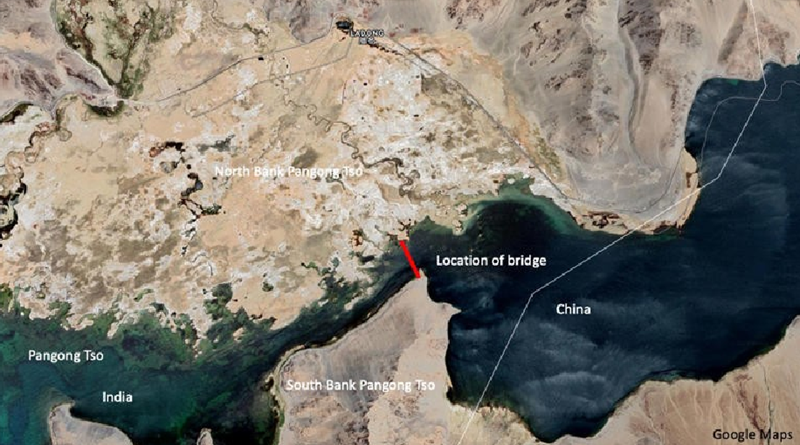

New Delhi: China has completed the construction of a 400-meter bridge near Pangong Lake, situated in territory it has controlled since 1958. Recent satellite imagery from July 22 shows the bridge is now operational, with light motor vehicles using it. This strategic infrastructure, located close to the Line of Actual Control (LAC) between India and China in Ladakh, enables quicker movement of Chinese troops between the North and South banks of Pangong Lake.
Previously, the People’s Liberation Army (PLA) had to navigate the entire eastern section of the lake to reach conflict zones, a process that extended travel time significantly. The new bridge provides a direct and shorter route, potentially reducing travel distance between the lake’s banks by 50-100 kilometers and enhancing rapid deployment capabilities.
In response, India’s External Affairs Ministry reiterated its stance on the area, stating that the bridge is being constructed in a region under what India considers illegal occupation by China for approximately 60 years. India has not recognized this occupation. Satellite images also reveal that the bridge is linked to an existing road network on the North bank of Pangong Lake, which leads to Khurnak Fort, a historic Tibetan structure. On the South bank, the bridge connects to a new road leading to Rutog, a Chinese garrison town and munitions hub.
This development follows the violent clashes that occurred along the LAC starting in May 2020, including the deadly Galwan Valley incident. In response, India has accelerated its infrastructure development in Ladakh, including building tunnels for year-round access. The Indian government invested heavily in frontier infrastructure, with significant projects underway to bolster defenses and connectivity in the region.
FOLLOW FOR MORE.


https://www.wpsue.com WPS Office: 一站式办公服务平台: 新升级,无广告,AI办公更高效. 立即下载. 登录使用. WPS 365: 面向组织和企业的WPS 365: 一站式AI办公,生产力即刻起飞. 了解更多. 咨询,记忆体占用低,体积轻运行快. 将文字、表格、演示、PDF等融合为一个组件。
有道词典是由网易有道出品的全球首款基于搜索引擎技术的全能免费语言翻译软件。简介. 支持中文、英语、日语、韩语、法语、德语、俄语、西班牙语、葡萄牙语、藏语、西语等109种语言翻译。拍照翻译、语音翻译、对话翻译、在线翻译、离线翻译更顺畅。更多的翻译 https://www.youdaoo.com
有道词典是由网易有道出品的全球首款基于搜索引擎技术的全能免费语言翻译软件。简介. 支持中文、英语、日语、韩语、法语、德语、俄语、西班牙语、葡萄牙语、藏语、西语等109种语言翻译。拍照翻译、语音翻译、对话翻译、在线翻译、离线翻译更顺畅。更多的翻译 https://www.fanyim.com
I’m really enjoying the design and layout of your website.
It’s a very easy on the eyes which makes it much more enjoyable for me to
come here and visit more often. Did you hire out a developer to create your theme?
Fantastic work!
I was suggested this web site by my cousin. I am not sure
whether this post is written by him as nobody else know such detailed about my
problem. You are amazing! Thanks!
Excellent weblog right here! Additionally your site rather a lot up very
fast! What host are you the usage of? Can I am getting your associate hyperlink on your host?
I want my website loaded up as quickly as yours lol
109829 938823The posh distributed could be described as distinctive; customers are really yearning for bags is actually a Native aspirations. Which strange surroundings is built that is to market diversity furthermore importance with travel and leisure market trends. hotels particular offers 852808
If you want to get a good deal from this article then you have to apply such strategies to your won webpage.
Pretty nice post. I just stumbled upon your blog and wanted to
say that I’ve truly enjoyed surfing around your blog posts.
After all I will be subscribing to your rss feed and I hope you write again very soon!
It’s really a great and helpful piece of info. I am satisfied that you shared this useful information with us.
Please keep us informed like this. Thank you for
sharing.
Peculiar article, exactly what I was looking for.
Send DM’s on Twitch – $30/hr . Do you use the streaming platform Twitch? If you do, would you like a job working for companies replying to chat messages on their channel? We have a lot of businesses right now hiring live chat assistants to work on their Twitch accounts, replying to customer inquiries. You will be given their account access as well as being told what to reply to the most commonly asked questions. Twitch is a huge growth channel for many businesses so they are hiring a lot of people all over the world for these jobs and the pay is very good. Read more details here : http://chat-assistant.advertising4you.co.uk
253455 144883Spot on with this write-up, I should say i believe this exceptional internet site needs a lot far more consideration. Ill probably be once once more to learn a terrific deal much more, many thanks that details. 861948
$950 per week for posting photos on Instagram ! The rise of Instagram has given new wings to fashion bloggers and other artists. Fashion blogging is the most popular category on Instagram. And that’s why you’re getting a chance to make money by helping one of those fashion bloggers. Read full details here: http://social-media-jobs.advertising4you.co.uk
Hi there mates, pleasant article and pleasant urging commented here, I am truly enjoying by these.
Excellent post however I was wondering if you could write a litte more on this topic?
I’d be very thankful if you could elaborate a little bit
more. Appreciate it!
I read this article fully regarding the difference of most up-to-date and preceding technologies, it’s
amazing article.
128382 541417I must test with you here. Which is not 1 thing I normally do! I enjoy studying a submit that will make people believe. Also, thanks for permitting me to comment! 664467
You made some good points there. I looked on the internet for the subject matter and found most people will go along with with your blog.
Hi, constantly i used to check website posts here in the early hours in the morning, for
the reason that i love to gain knowledge of more and more.
Your style is so unique compared to other folks I’ve read
stuff from. Thank you for posting when you’ve got
the opportunity, Guess I’ll just book mark this blog.
I’m truly enjoying the design and layout of your site. It’s a very easy on the eyes which makes it
much more pleasant for me to come here and visit more often. Did you hire out a designer to create
your theme? Outstanding work!
Its such as you learn my thoughts! You appear to know so much about this, such as you wrote the e-book in it or something.
I think that you just could do with a few percent to pressure the message
house a little bit, however instead of that, that
is magnificent blog. A great read. I will definitely be back.
Thank you for every other great article. The place else may anyone get that kind of info in such a perfect method
of writing? I’ve a presentation next week, and I am at the look for such info.
Simply want to say your article is as astounding.
The clearness in your post is just spectacular and i can assume you’re an expert on this subject.
Fine with your permission allow me to grab your RSS feed to keep up
to date with forthcoming post. Thanks a million and please
carry on the gratifying work.
Appreciating the commitment you put into your site and in depth information you present.
It’s nice to come across a blog every once in a while that
isn’t the same outdated rehashed material. Great read!
I’ve saved your site and I’m adding your RSS feeds to my Google account.
$700 per week for planning holidays ! Can’t go on a holiday or travel abroad ? Still, sitting at home and watching videos and photos of famous travel destinations and trying to feel it? Well, at least, now you can make an income by doing so. We have a network of tourism companies and holiday resort owners who are looking for remote workers to manage posting content on their social media account. See full details here: http://social-media-jobs.advertising4you.co.uk
Fantastic blog you have here but I was curious if you knew of any
user discussion forums that cover the same topics discussed in this article?
I’d really love to be a part of online community where I can get opinions
from other knowledgeable individuals that share the same interest.
If you have any recommendations, please let me know. Thanks!
I visit everyday a few websites and blogs to read posts, except
this blog gives feature based writing.
Please let me know if you’re looking for a writer for your blog.
You have some really great articles and I feel I would be a
good asset. If you ever want to take some of the load off, I’d really like to write some articles for your blog in exchange for
a link back to mine. Please send me an e-mail if interested.
Many thanks!
Thanks designed for sharing such a pleasant idea, post is
fastidious, thats why i have read it completely
It’s hard to find educated people for this topic, however, you sound like you
know what you’re talking about! Thanks
I think the admin of this web page is in fact working hard
for his site, for the reason that here every material is quality based information.
I used to be recommended this web site by my cousin. I’m no longer
sure whether or not this post is written by way of him as
nobody else recognize such targeted approximately my trouble.
You’re wonderful! Thanks!
Now I am going to do my breakfast, after having my breakfast coming yet again to read further news.
I am in fact grateful to the holder of this web page who has
shared this impressive article at at this place.
This post is worth everyone’s attention. Where can I find out more?
Instant access to millions of digital products you can brand and sell as your own 🚀 ! ✓ Expansive kids’ product collection ! ✓ Hundreds of thousands of professionally written eBooks ! ✓ Fully customizable guides and workbooks ! ✓ PowerPoint and presentation templates ! ✓ Infographics and visual templates ! ✓ High-definition logo templates ! ✓ Print-on-demand T-shirt designs ! ✓ Video editing assets and motion graphic ! ✓ Graphic design resources ! ✓ Social media content packs ! ✓ Trending digital products across multiple niches ! ✓ Business and productivity templates ! ✓ Digital art collections ! ✓ Music producer assets ! ✓ Cyberpunk-themed collections ! ✓ Advanced 3D printing files ! ✓ Planner & journal creator ! ✓ ChatGPT prompt collection ! ✓ Fitness and wellness mega bundles ! And much more to explore here : http://unlimited-ai-tools.advertising4you.co.uk
Hey! Would you mind if I share your blog with my twitter group?
There’s a lot of people that I think would really enjoy your
content. Please let me know. Many thanks
It’s amazing to visit this site and reading the views of all colleagues concerning this
post, while I am also eager of getting knowledge.
I am really glad to glance at this weblog posts which contains
plenty of valuable data, thanks for providing such data.
Hurrah! After all I got a webpage from where I be able to genuinely get
useful data concerning my study and knowledge.
Hey fantastic blog! Does running a blog
similar to this take a great deal of work? I have virtually no expertise in coding but I had been hoping to start my own blog soon. Anyways,
if you have any suggestions or techniques for new blog owners please share.
I understand this is off subject nevertheless I just had to ask.
Many thanks!
Does your website have a contact page? I’m having trouble locating it but, I’d like to send you an email.
I’ve got some ideas for your blog you might be interested in hearing.
Either way, great blog and I look forward to seeing it grow
over time.
When someone writes an piece of writing he/she retains the thought of a user in his/her brain that how a user can be aware of it.
Thus that’s why this paragraph is outstdanding.
Thanks!
Hi, just wanted to tell you, I loved this blog post.
It was funny. Keep on posting!
624855 707756I consider something really unique in this website . 79838
Watch stunning models in real-time and explore your deepest desires. Enjoy Unlimited Sexy Webcams & Chat with Hot Girls Waiting for You. Enjoy your free time here: http://live-chat.advertising4you.co.uk
The web optimization trade is ALWAYS altering.
It’s awesome to visit this web site and reading the
views of all friends regarding this piece of
writing, while I am also eager of getting know-how.
Hey there! This is kind of off topic but I need
some help from an established blog. Is it tough to set up your own blog?
I’m not very techincal but I can figure things out pretty quick.
I’m thinking about creating my own but I’m not sure where
to start. Do you have any points or suggestions? Cheers
I read this article fully regarding the difference of most recent and earlier technologies, it’s remarkable article.
bookmarked!!, I love your website!
I was curious if you ever considered changing the structure
of your site? Its very well written; I love what youve got to say.
But maybe you could a little more in the way of content so people could connect with it better.
Youve got an awful lot of text for only having one or two images.
Maybe you could space it out better?
I wanted to thank you for this excellent read!! I definitely enjoyed
every bit of it. I have you saved as a favorite to check
out new things you post…
Hi there mates, pleasant paragraph and fastidious urging commented at this place, I am really enjoying by these.
Instagram Chat Assistant – $250 a Day. Several online retailers are looking to hire additional Instagram Chat Assistants to help drive more sales through Direct Messages sent to their Instagram accounts. This is online work that can be done from anywhere, full training is provided and the pay is $250 a day. Hiring workers from all countries. Read full details here to complete your application if you are interested. You can find more info here: https://saveapp.store/cl/i/d2opmo
I constantly spent my half an hour to read this webpage’s
articles or reviews daily along with a mug of coffee.
Hi there, this weekend is good designed for me, for
the reason that this point in time i am reading this great informative paragraph here at my home.
Its such as you learn my thoughts! You seem to understand a lot approximately this, like you wrote the e
book in it or something. I feel that you simply can do with some % to drive the message home a bit, however instead of that, that is excellent blog.
An excellent read. I’ll definitely be back.
It is not my first time to visit this web site, i am visiting this
web page dailly and get pleasant data from here everyday.
This is a really good tip especially to those fresh to the
blogosphere. Simple but very accurate information… Appreciate your sharing this one.
A must read post!
Woah! I’m really enjoying the template/theme of this site.
It’s simple, yet effective. A lot of times it’s very difficult
to get that “perfect balance” between superb usability and visual
appearance. I must say you’ve done a awesome job with this.
Additionally, the blog loads extremely fast
for me on Firefox. Exceptional Blog!
Hey there! Would you mind if I share your blog with my twitter group?
There’s a lot of people that I think would really appreciate your content.
Please let me know. Thanks
hello!,I like your writing so a lot! percentage we communicate extra about your article on AOL?
I need a specialist on this space to unravel my problem.
May be that is you! Having a look ahead to peer you.
Have you ever considered writing an ebook or guest authoring on other blogs?
I have a blog based upon on the same ideas you discuss and would love
to have you share some stories/information. I know my audience would enjoy your work.
If you are even remotely interested, feel free
to shoot me an email.
Thanks on your marvelous posting! I seriously enjoyed reading it, you might be a great author.I
will ensure that I bookmark your blog and will often come back very soon. I want to encourage continue your great writing,
have a nice weekend!
Thanks for the auspicious writeup. It in fact used to be a entertainment account it.
Glance complicated to far delivered agreeable from you!
However, how could we keep in touch?
It’s impressive that you are getting ideas from this piece of writing as
well as from our argument made at this time.
I know this if off topic but I’m looking into starting my own weblog and
was wondering what all is required to get set up? I’m assuming
having a blog like yours would cost a pretty penny? I’m not
very internet savvy so I’m not 100% sure. Any recommendations or advice would be
greatly appreciated. Thank you
Thank you for any other great post. The place else
may just anybody get that type of info in such an ideal method of writing?
I’ve a presentation next week, and I’m at the search for such info.
It’s an amazing article designed for all the web visitors; they will obtain advantage
from it I am sure.
It’s nearly impossible to find educated people about this topic, however,
you sound like you know what you’re talking about!
Thanks
Hi there, its nice piece of writing concerning media print,
we all be familiar with media is a fantastic source of information.
I enjoy what you guys are up too. This sort of clever work and exposure!
Keep up the wonderful works guys I’ve you guys to my
blogroll.
I think this is one of the most significant information for me.
And i am glad reading your article. But should remark on few general things, The website style is perfect, the articles is really great : D.
Good job, cheers
What’s up, just wanted to mention, I liked this post.
It was inspiring. Keep on posting!
I blog quite often and I really thank you for your
content. This great article has really peaked my interest.
I will book mark your site and keep checking for new details about once per week.
I subscribed to your RSS feed as well.